Common layer API
All dotAtlas layers share some common API methods and properties. This part of the reference describes them in detail.
Point properties
x, y
The x and y coordinate of the point, required.
There are no constraints on the coordinate values, so you can use a coordinate system that makes the most sense for your data. dotAtlas will ensure that the initial view includes all points from all layers.
When you mutate the x or y property of a
specific point object, call the update() and then the
redraw() method to see the changes
on the screen.
Layer properties
points
The array of 2d points to display on this layer.
Each point is represented by a JavaScript object with the mandatory x
and y properties. Specific layer types require other properties
to be present in the point object, such as the
elevation property in the
elevations layer or the markerColorproperty
in the markers layer.
When different layers share points of the same coordinates, for example when elevations, markers and labels need to be drawn for each point, you can set the same array of points for all layers.
visible
Determines if this layer is visible. Set this property to false
to hide the layer. When a layer is hidden, its layer-specific events, such as
onPointClick will not be triggered.
opacity
Opacity level of this layer.
The default opacity value is 1.0, which will render a fully opaque layer.
A value of 0.0 will hide the layer. If the layer's opacity is 0.0,
its layer-specific events, such as onPointClick
will still be triggered.
pointHoverRadiusMultiplier
How much the point's active area should be larger than the actual point.
To improve usability of point-related events, the point's active area can be made larger than its on-screen size. This property determines what the scaling factor should be.
Events
onPointHover
Triggered when the user hovers over a specific point of this layer, when the mouse pointer moves to an area without points or moves out of the visualization area completely.
In addition to the common event details properties, this event comes with the following additional properties:
- points
-
An array of point objects hovered by the user. The array may contain zero, one or more points. In case the array contains more than one point, the points will be sorted in the increasing distance from the mouse pointer location.
onPointClick
Triggered when the user clicks on a specific point of this layer.
In addition to the common event details properties, this event comes with the following additional properties:
- points
-
An array of point objects clicked by the user. The array may contain one or more points. In the latter case, the points will be sorted in the increasing distance from the mouse pointer location.
onPointDoubleClick
Triggered when the user double-clicks on a specific point of this layer.
In addition to the common event details properties, this event comes with the following additional properties:
- points
-
An array of point objects double-clicked by the user. The array may contain one or more points. In the latter case, the points will be sorted in the increasing distance from the mouse pointer location.
onPointHold
Triggered when the user clicks and holds mouse button on a specific point of this layer.
In addition to the common event details properties, this event comes with the following additional properties:
- points
-
An array of point objects click-and-held by the user. The array may contain one or more points. In the latter case, the points will be sorted in the increasing distance from the mouse pointer location.
Methods
update()
Notifies dotAtlas that some property has been changed for some of the points of this layer. Upon the next redraw, dotAtlas will refresh its external buffers and reflect the change on the screen.
layer.update(prop);
The following prop parameter values are supported:
prop parameter |
layer type | use when... |
|---|---|---|
|
all types |
you change point coordinates represented by the |
|
elevation |
point's |
|
marker |
point's |
|
marker |
point's |
|
marker |
point's |
|
marker |
point's |
|
label |
point's |
|
label |
point's |
|
label |
point's |
|
label |
point's |
|
label |
you change label point |
|
outline |
point's |
The typical workflow for updating point properties will look like this:
const markers = dotatlas.get("layers")[0];
const points  = markers.get("points");

points[0].x += 0.1;
points[0].y += 0.1;
points[0].markerSize *= 1.2;

points.update("xy");
points.update("markerSize");
dotatlas.redraw();
Note that if several layers share the same point instances, you still need to notify each involved layer about the changed properties:
const points = [
  { x: 0.0, y: 0.0, elevation: 0.5 },
  { x: 0.0, y: 0.5, elevation: 0.3 }
];

const elevations = DotAtlas.createLayer({
  "type": "elevation",
  "points": points
});

const markers = DotAtlas.createLayer({
  "type": "marker",
  "points": points
});

const dotatlas = DotAtlas.embed({
  "element": document.getElementById("dotatlas"),
  "layers": [ elevations, points ]
});

points[0].x += 0.1;
points[0].y += 0.1;
points[0].elevation += 0.1;

elevations.update("elevation");
elevations.update("xy");
markers.update("xy");
within()
Computes points lying within the requested 2d circle.
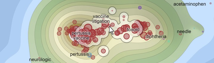
A group of points obtained from the circle() method. The start point
is marked with the mouse pointer. The method includes all points lying within a certain
distance from the start point. Therefore, isolated within-circle points can also be
included in the group. Compare how the cluster()
method returns a different set of points based on the same start point.
const withinCircle = await layer.within(params);
This method returns a Promise resolving to the array of points inside the circle.
The params literal object contains the definition of the circle:
-
startX,startY -
Coordinates of the center of the circle. The coordinates must be in the same space as coordinates of the layer's points.
radius-
Circle radius, relative to the dimension of the bounding box of the point's layer,
0.05by default. The dimension of the bounding box is assumed to be the minimum of the box width and height.For example, if the point's bounding box is a
2.5x2.0rectangle, andradiusis0.1, then all points within the distance of0.2from the center will be returned. sortByDistance-
If
true, the returned points will be sorted by the increasing distance to the center. If this property is not defined,falsewill be assumed and points will be returned in an arbitrary order.
You can use this method to build a simple mechanism for selecting multiple points at once.
Alternatively, use the cluster() method to find
non-circular density-based clusters of nearby points.
The typical invocation looks like this:
const markers = dotatlas.get("layers")[1];
const points = await markers.within({
  "startX": 0.2,
  "startY": 0.5
});
console.log(`${points.length} point(s) found.`);
cluster()
Computes a density-based cluster of nearby points around some start point:
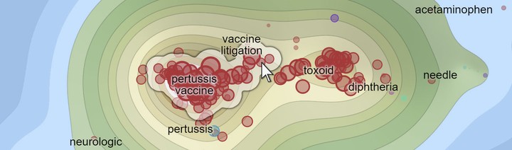
A cluster of points obtained from the cluster() method. The start point
is marked with the mouse pointer. Notice how the cluster is asymmetrical and follows
the density of the markers. Non-connected outlier points are not included in the cluster.
Compare how the within()
method returns a different group of points based on the same start point.
const cluster = await layer.cluster(params);
This method returns a Promise resolving to the array of points in the cluster.
The params literal object contains parameters for the clustering algorithm:
-
startX,startY -
Coordinates of the start point from which to build the cluster. If the point lies inside a densely-populated area, most points in that area will be included in the cluster. If the point does not have any neighbors, the cluster will contain only that point.
radius-
Defines the desired size of the cluster,
0.4by default. The larger the radius, the larger the cluster. In most cases, a value from the0...1range will produce the best results. In an interactive selection scenario, you can let the user change the size and dynamically re-compute and present the cluster. maxClusterRadius-
Defines the maximum allowed cluster radius, relative to the bounding box of all points in the layer,
0.1by default. The limit on the maximum cluster radius prevents a situation where all points in the layer are included in the cluster.
You can use this method to build a mechanism for selecting entire regions of related points
on the map. As opposed to the within() method,
this method will usually return non-circular clusters that match the densely-populated
region around the start point.
See the implementation of the Selection plugin for example invocations of this method.